T2K

Boundary Waters Fur Trade (La Verendrye) Route

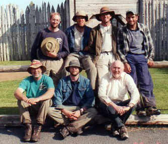
The Boundary Waters Fur Trade Route was used to establish the United States - Canada international border from Lake of the Woods to Lake Superior. In June 2000, seven of us retraced that portion of the route starting at Birch Point, about 2 miles east of Fort Frances on the south side of Rainy Lake, and finishing at Grand Portage on Lake Superior.

  Days on trip: 17
Trip Distance measured from maps: 272 miles
Average miles per day: 16
Number of Portages: 42
Number of Lakes/Rivers: 45

Note: Selecting the date in the following table will show details and historical information pertaining to that day's travel. Included in the historical portion are notes from the diary of John Macdonell. (These notes are indicated by the date and the initials 'JMcD'.) John Macdonell was a young clerk/fur trader who in 1793, signed on with the Northwest Company in Montreal and was assigned to winter at a fort near the Assiniboine (Upper Red) River. On May 25, 1793, he left Montreal headed for his assigned place. He left Grand Portage on August 5th, arrived at Fort La Pluie on August 21st and at his final destination on October 8, 1793. His diary is reprinted in the book 'Five Fur Traders of the Northwest' (Ref. 11.)

TRIP SUMMARY BY DAY

Date Location Distance Including Portages,
Miles
Number of Portages Portage Length,
Rods
Comments
June 12 Rainy Lake 0.0 0 0 Arrived at Birch Point Campgound. Original plans were to leave from Ft. St. Pierre in Fr. Frances, but the reconstructed fort was not open.
June 13 Rainy Lake; Birch Point to Sunrise Campground on Dove Bay 13.7 0 0 Started in nice weather. Wind started blowing at mid-morning and became strong and cold by lunch.
June 14 Rainy Lake; Dove Bay to Beaver Lodge campsite on Big Island in Kempton Bay 18.4 0 0 Paddled thru Brule Narrows to Kempton Bay. Rained in morning and evening. Saw black bear cub.
June 15 Kempton Bay on Rainy Lake to Mica Island on Namakan Lake 17.8 1 35 Windy. One canoe swamped near Finger Bay on Rainy Lake. After three hour degrade (wait on shore), wind died down and we were able to paddle to Mica Island via Kettle Falls.
June 16 Mica Island 0 0 0 Windy and cold. Degrade - could not paddle today.
June 17 Namakan Lake thru Sand Point Lake to Little Lake Vermillion 25.1 0 0 Cold but not windy in morning. Became breezy later but did not cause problems.
June 18 Little Lake Vermillion thru Loon River and Loon Lake to east of Snow Bay on Lac La Croix 18.6 2 130 Raining when we got up. Weather improved during day. Saw doe and fawn on island at entrance to Loon River.
June 19 Lac La Croix thru Iron Lake to Crooked Lake 27.5 2 220 Picked up Quetico permits and Canadian licenses. Ate lunch on historic Eastbend Island. No empty campsites on Iron Lake. Forced to camp in undesignated area on Crooked Lake because of high winds and waves.
June 20 Crooked Lake and Basswood River to Basswood Lake 23.5 4 450 Thunder and rain delayed start. Paddled in rain for parts of the day. Saw historic Table Rock and Picture Rock. Hit heavy winds and waves on Basswood. Small turtles were coming on shore to dig holes to lay eggs.
June 21 Basswood Lake to Wind Bay on Basswood 8.7 0 0 Wind and rain in the morning. Broke camp at 6:15 p.m. Large snapping turtle preparing to lay eggs at Wind Bay campsite.
June 22 Wind Bay (Basswood) thru Wind Lake, Moose, Newfound and Sucker Lakes to Birch Lake 12.4 3 310 Rained during the night. Stopped at Sommers Canoe Base to pickup food drop. Saw eagles feeding young in nest and many 'close-ups' of loons. Celebrated Doug's birthday with fish fry on Birch Lake.
June 23 Birch thru Carp, Melon, Seed, Portage, Knife, Ottertrack and Swamp Lakes to Saganaga Lake 20.1 8 275 Rained in morning and evening; winds calm. Passed sites of Dorothy Moliter and Bennie Ambrose homesteads.
June 24 Saganaga Lake, Granite River and Maraboeuf Lake to campsite near Devil's Elbow on Granite River 14.3 3 99 Light wind on our back crossing Saganaga Lake. Heavy blowdown on last portage of day.
June 25 Gneiss Lake, Granite River, Clove Lake, Pine River, Gunflint Lake, Little Gunflint Lake, Little North Lake, North Lake 18.3 8 333 Wind was mild all day but rained after we got into camp. Swamp portage lived up to its name; channel between Little North Lake and North Lake made you feel like you were with the voyageurs. Hi-lite of the day was watching a cow moose and her two calves.
June 26 North, South, Rat, Rose, Rove, Watap and Mountain Lakes 17.3 4 897 Encountered some strong winds and sailed on Watap Lake. Did historic Height of Land and Long Portages. Very heavy rains while setting up camp.
June 27 Mountain, Fan, Vaseux, Moose, North Fowl and South Fowl Lakes 13.3 4 400 Encountered cross-winds at bay inlets that made paddling difficult. Beautiful campsite on South Fowl Lake.
June 28 South Fowl Lake, Pigeon River, Ft. Charlotte 14.1 2 390 Fowl Portage (0.9 miles) took about two hours because of large amount of downed trees. Camped at site of Ft. Charlotte.
June 29 Grand Portage from Ft. Charlotte to Grand Portage Depot 8.5 1 2720 DID THE GRAND PORTAGE! Took 6.5 hours including lunch.
17 days TRIP TOTALS 272.6 42 6259 6259 rods = 19.6 miles

Intro, History, Equipment, Personal Equipment, Menus
Exit T2K


Last updated: August 2, 2000
Reformatted: Nov. 2013