2. Rapids: Class I-VI
3. Skill of Paddler: Intermediate Open Canadian
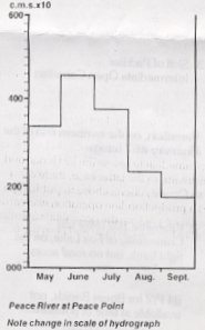
2. Kilometer 102 (Mile 65) Community of Fox Lake, on the right bank, but no road access
84 K Mount Watt
84 J Vermillion Chutes
84 I Lake Claire
84 P Peace Point
N.T.S. 1:50,000 scale
84 J/7 for Vermilion Chutes and Falls
84 P/2 for Boyer Rapids, not available at the time of publication (1980's)
Provincial Access Maps
84N/K; 84 O/J; 84 P/I
Chart 6321 Peace River-Lake Athabasca and Slave River to Jackfish river (scale 1:63,360)
Below Fort Vermilion, the Peace River flows in a broad, flat valley. Good campsites, although not a frequent as on the upper reach, are to be found along the sandy beaches.
Generally the scenery is rather uniform -- extremely wide river, low terrain and long seemingly never-ending bends. However, the Vermilion Chutes and Falls and the Boyer Rapid reach are spectacular.
The first major landmark is the confluence of the Wabasca River, on the right at km 58 (Mile 36). Two and one half kilometres (1-1/2 miles) downstream of the Wabasca confluence is Donnelly Island. This gives the first advanced warning of the approach of the Vermilion Chutes and Falls, which lie 20 km (13 miles) downstream. Further warning is given by Adam's Landing on the left bank. From Adam's Landing a track leads north through the Jean D'Or Indian Reserve to Highway #568. Next appear a string of mid-stream islands, starting 10 km (6 miles) above the chutes. Avoid staying north of these islands for too long because their lower end is dangerously close to the northern end of the chutes. At the first sound of the chutes, which can be heard about 2 km (1 mile) upstream, it is advisable to immediately paddle over to the south (right) bank.
As one approaches a group of buildings (Forestry Cabin) on the right bank, huge boulders stretching across the river at the head of the chutes will be clearly visible. These rapids angle across the river, with the lower end on the right. The portage trail begins approximately 135 km (150 yds.) above the white water. The trail angles up to a road cut which runs for about 8 km (5 miles) alongside the river. In the clearing at the jucntion is an old trapper's cabin, but the 1973 Canoe Alberta crew do not recommend it as overnight accommodations -- a smoking stove and hordes of mosquitoes not being conducive to a restful night!
The selection of a route by-passing the chutes will be largely dependent upon the water-level. An eight kilometre (5 mile) portage trail follows the right bank around both the chutes and the falls. At extremely high water the current becomes very strong, standing waves submerge all but the largest boulders and the lower levels of the river bank are flooded. The chutes would become a Class V-VI rapid and the long portage would be necessary. At low to medium water level, the Canoe Alberta crew were able to partially run and line the chutes. However, some skillful manoeuvring was necessary together with scrambling over log jams along the shore. At medium water they were considered Class II-III. At low water the chutes on the right are probably a Class IV rapid, requiring precise manoeuvring to navigate the few open channels winding throught a maze of huge boulders. At any water level, the falls must be portaged!
Vermilion Falls are caused by the river falling over a series of limestone ledges. At low water, the falls are 4-5 m (12-15') high but at high water their height is greatly reduced. The Falls are not continuous all the way across the river, but are interrupted by higher portions showing above the water. The N.T.S. 1:250,000 map is misleading regarding the length of the falls. The N.T.S. 1:50,000 map which shows a much shorter set is more accurate.
At high water, the longer portage trail above the river would be used to skirt the falls. This was the Canoe Alberta crew's experience at medium flow. "After our usual scouting session, we paddled along the right shore to the log jam near the top of the falls. At this point, we lined around the logs and hauled our boats upon the rock shelf about ten feet upstream of the first ledge." The 69 m (75 yard) portage around the falls is very easy going at medium water level, for there is lots of room to walk on the rock shelves along the shroe. There are two put-in points: immediately below the last ledge and about 183 m (200 yards) further downstream. In the latter case, there are a couple of small chasms to be crossed, so Canoe Alberta chose to put-in right below the falls. In reloading the canoes, a production-line operation was carried out as follows: one person stood in the canoe packing the gear, while another, perched precariously on a small shelf, acted as middle man and atop the main platform was the third member of the chain.
Below the falls, the Peace River reverts to its former characteristics -- slow-moving, averaging 1.6 km (1 mile) wide with very low banks, and the occasional sandy beach for a campsite. At kilometre 102 (Mile 65) is the isolated community of Fox Lake where limited supplies may be purchase at the Hudson's Bay Post.
Below Garden Creek the N.T.S. maps show interesting remnants of old abandoned meanders, but in such low terrain, they are not visible from the river. At kilometre 288 (Mile 180), the river begins to flow through a gypsum formation forming high white cliffs, and on the next right-hand bend are the Boyer (Bouille) Rapids. Their boulders and standing wavers may be easily avoided by staying to the left side of the river, adjacent to an island, or by hugging the inside of the corner. Thirteen kilometres (8 miles) downstream is Peace Point on the left bank of Wood Buffalo National Park. A loose-surfaced road goes north from Peace Point, via Pine Lake Ranger Station to Fort Smith, N.W.T., and thence via N.W.T. Highway #5 to Hay River and the Mackenzie Highway.