2. Rapids: Class 1
3. Skill of Paddler: Novice Open Canadian
2. Kilometer 190 (Mile 119) Secondary road west of North Star
3. Kilometer 254 (Mile 159) Secondary road #692 to Hawk Hills (6 km downstreat of the Notikewin River at a pipeline crossing).
4. Kilometer 381 (Mile 238) Ferry on Highway #697 to Paddle Prairie
83 M Grande Prairie (Note: Original document stated 83 N.)
83 N Winagami
84 C Peace River
84 K Mount Watt
84 F Bison Lake
Provincial Access Maps
83M/L; 83N/K; 84 F/C; 84 N/K

The town of Peace River at Kilometer 99 (Mile 62) is an interesting stop-over. It is one of the earliest settlements in the province, having some eighty inhabitants when Alexander Mackenzie wintered here at Fort Forks in 1792, after ascending the river from Lake Athabasca. There are two campsites in the town, the provincial site being on the east bank. One of the interesting places to visit is the grave of "Twelve Foot" Davis, an old prospector who made a fortune in gold by mining a claim only twelve feet wide.
Downstream of Peace River, the river flows through farmland but the valley sides remain relatively unaltered from their natural state. Walleye, goldeye and ling are said to be plentiful at the mouths of tributary streams. The 1973 Canoe Alberta crew saw two black bears and numerous deer, moose and wolf tracks along the river banks. The river water is not clean enough to drink without purification because the tributaries drain famland, but clear cold springs can be found by the watchfull paddler.
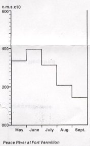
Since the building of the Bennett Dam on the upper Peace, the volume of water in the lower reaches has been reduced and that, together with the river's natural tendency to slow down in the mature stage, has produced many exposed sand and gravel bars. Many of the former channels around islands now exist only at extremely high water. It is important to check the relevant N.T.S. map for the channel with the fewest marked gravel bars, in order to avoid long portages along channels which have degenerated into a maze of sand bars.
Although Highway #35 from Peace River to High Level parallels the river on the west, it does so at a distance of 30 km (20 miles). The three most convenient access points are #3, 4 and 5.
The recommended pull-out point is the Provencial Recreation Area at the Highway #67 bridge, 6.5 km (4 miles) west of the settlement of Fort Vermilion which lies on the right bank.