Peace River
Carcajou to the Fifth Meridian
The following excerpts are taken from a pamphlet given out at the Ft. Vermilion Heritage Center, Ft. Vermilion, Alberta, Canada.
The Mighty Peace: Carcajou ~ Fifth Meridian
Research & Design by K. Gabriel
Sketches by A. Yeomans and V. Hopkins
Produced by:
Heritage Committee
Fort Vermilion Agricultural Society
with
Employment and Immigration Canada
Student Employment Experience Development
(SEED) Program
August 1994
| Location | Comments |
|---|---|
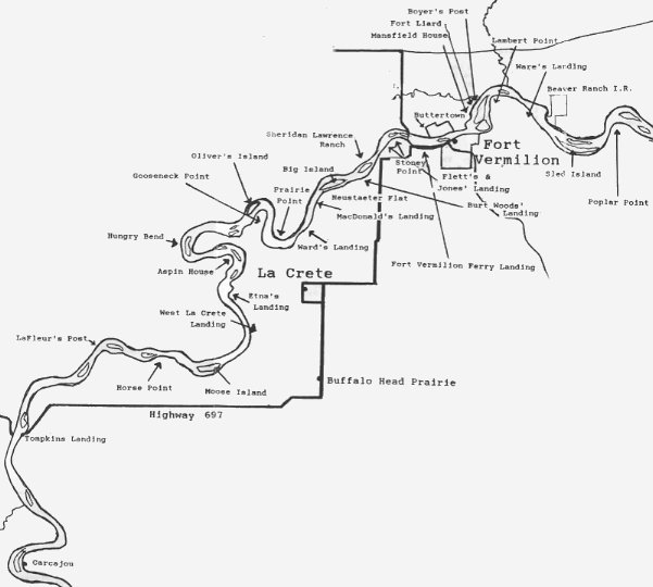
| Carcajou | Originally Carcajou was on the east side of the Peace River and called Wolverine Point by the fur traders. There were six or seven cabins, a store and a graveyar. It is now located on the west side of the river. |
| Tompkins Landing | Prior to the consturction of Highway 697, it was located upstream from its present location. It was first used by the Paddle Prairie Metis Settlement. An ice bridge is used to cross the river in the winter and a ferry between break-up and freeze-up. |
| La Fleur's Post | Established by J. B. La Fleur in 1798 for the Northwest Company to trade with the Beaver Indians. Played an important role in the fierce competition between the Northwest Company and Hudson's Bay Company betrween 1812 and 1815. The post was abondoned between 1828 and 1830. Also known as Upper Fort Vermilion or Fort Vermilion I. |
| West La Crete Landing | For many years is was the river boat landing for the people of Buffalo Head Prairie and La Crete. |
| Etna's Landing | Named after Etna Rivard, the oldest of four Rivard brothers. It wa used as a river boat landing for the La Crete area. It is also known as Cook's Landing after another of the Riard brothers. Some local people now call it Atlas Landing. |
| Aspin House | Establiashed by John Finlay in 1792 for the North West Company replacing the 'Old Establishment', Boyer's Post. It was also known as Finlay's Post, New Establishment, Old Aspin Fort and Fort du Tremble. |
| Gooseneck Point | Also known as Wiebe's Flat, it was hayed in the 1930's. |
| Oliver's Island | Mr. Oliver logged trees here for use by the Hudson's Bay Company to build the river boat S.S. Peace River. It was launched on May 19, 1905. Logs were also used to build the store and flour mill. |
| Prairie Point | The Lawrences pastured cattle here in the early 1920's. Jim Lawrence had a farmsted, sawmill and cattle yard at Prarie Point Landing on the southwest side of The Point. |
| Sheridan Lawrence Ranch | 'The Ranch' included a large house, school, store, flour and lumber mills and other farm buildings. The school house and land was designated a Rigistered Hiastoric site by the Provincial Government in 1978. |
| Stoney Point | The first site of the Experimental Farm established in 1907 on the Robert Jones' farm. It was moved to higher ground on the west side of Ft. Vermilion after the 1934 flood. |
| Fort Vermilion Ferry Landings | Two landings and three ferries served the Fort Vermilion area. The first landing was in front of the Old Bay House and used a cable to guide it across the river. There were three towers, one on the south shore, one on the island and on on the north mainland. ONe ferry carried the passengers to the island and another ferry took them across the reiver to Buttertown. The landing was moved upstream about one mile west of Fort Vermilion and was used until the bridge opened in 1974. The first ferry used a motor and a cable to guide it across the river. The last ferry had a tugboat attached. This ferry was later used at the Shaftsberry Crossing. |
| Buttertown | Buttertown is on the north side of the Peace River and is also known as North Vermilion Settlement. Its name comes from the fact that its residents make most of the butter for the surrounding area. The Hudson's Bay and Revillon Freres Stores once located there are gone, but the St. Louis Catholic Church and cemetery still remain. |
| Fort Vermilion | Fort Vermilion II was located on the present site. The name came from the red ochre deposites in teh vicinity. It was established as a Hudson's Bay Company trading post bewteen 1828 and 1830 by Paul Frases, a clerk at Fort Vermilion I and II. Fort Vermilion had two landings in town, one was in front of the Hudson's Bay store and the other in front of the Old Bay House that was built in 1905. Hudson's Bay Company was present in Fort Vermilion until 1988 when it sold its stores to a group of employyees called the North West Company! |
| Boyer's Post | This is believed to be the first trading post on the Peace River and was also called 'Old Establishment'. It was established in 1788 at the mouth of the Boyer River by Charles Boyer of the North West Company. It was important because it was near one of the best sources of buffalo in the Athabasca region. Alexander Mackenzie recorded in 1792 that the post garden included turnips, carrots and parsnips. M. Vandrieul, who surveyed the Peace River up to Boyer's Post replaced Boyer in 1789. The post remained open until 1792. |
| Fort Liard | Explorer Simon Fraser of the North West Company built this fort in 1802 on the north bank of the Peace River near the mouth Boyer River. David Thompson visited the fort in 1802, the same year the site was abandoned. |
| Mansfield House | This provisional post was built on the north bank of the Peace River in September 1802 by Thomas Swainn of the Hudson's Bay Company to compete with Fort Liard. The fierce competition from Fort Lieard and the lack of food forced the starving men to abandon Mansfield House on January 10, 1803 after only one season. |
| Location | Comments |
|---|---|
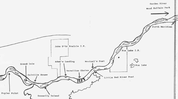
| Corville House | This Hudson's Bay Company post was founded in 1818 by Joshua Halcro near the mouth of the Wabasca River. It was describved as "a small sized dwelling house for the officers, a mems house and a store all in good repair." Colville House was named for Andrew Wedderburn Colville, brother-in-law of Lord Selkirk. La Fleur's North West Company Post was the nearest competition and it was located three days up river. Following the union of the two companies in 1821, the post was abandoned due to lack of trade. |
| Adam's Landing | River boat landing used by people travelling to and from John D'or Prairie. |
| Vermilion Rapids and Chutes | About 2 km above the rapids on the south bank is Vermilion Rapids Landing. Here begins a 14 km portage route that was used to transport freight and passengers to Little Red River. On old warehouse remins on the site. |
| Little Red River Post | The trading post was established around 1800 and was known as Fort de la Riviere Rouge, Red River Fort and Little Red River Fort. It was located at the mouth of the Little Red River, now called the Mikkwa River. The area was abondoned in the 1950's when the people relocated to Fox Lake. At the time it had a school, church, stores and dwellings. |
| Wentzel's Post | A North West Company post founded by John Stuart across from the mouth of the Little Red River. It operated from 1799 to 1803. |
| Fox Lake | The Fox Lake Indian Reserve land was set aside in 1914 and the community of Fox Lake was formed when the people from Little Red River moved there. |
| Fifth Meridian | A Hudson's Bay Company trading post was located on the south bank of the Peace at one time. Fifth Meridian, a longitude survey line established by the Dominion Land Survey, forms the western boundary of the Wood Buffalo National Park. |
Intro, Equipment, Route, Personal Equipment, History, Menus
Last updated: October 19, 2001
Exit Peace River Canoe Trip