This trip was originally scheduled as a trip for families of Scouters who passed away in 1998. That could not happen for a variety of reasons. Instead of canceling the trip, a small crew of scouts from two different troops traveled to Charles L Sommers Canoe Base for a Boundary Waters Canoe Area Wilderness trip. There were questions if even this crew would make the trip as the Boundary Waters Blowdown / Boundary Waters-Canadian derecho struck the base on July 4, 1999 and our scheduled arrival at the Base was July 26th. Fortunately, sufficient cleanup at the base and in the BWCAW occurred to allow us to make this trip three weeks after the blowdown.
Crew members were: Justin Rabold, Chris O'Toole and Ross Small (Mancos, CO). Adult leaders were Brand Wilson and Bill Erickson. Our Interpreter was Paul DeWitt.
The webpages in this series of Los Alamos Troop 22 Northern Tier canoe trips written about twenty years after the trips. The source materials were scrapbooks put together by me (Bill) after each trip. The scrapbook for this trip contained a map showing the route, photographs, a table of captions for the photos and a table showing trip daily details. Webpage contents are based on this information. The trip report was written using these references and personal recollections of the trip.
We arrived at Charles L Sommers Canoe Base on July 26. Upon arrival, we met our Interpreter, Paul DeWitt. After check-in there were many things to do to prepare for departure the next day: check out crew gear, pack food, attend training sessions, pack personal gear for the trip and of utmost importence, plan the route we would canoe.
Paul was a veteran Interpreter and was there to guide and teach the Scouts how to accomplish the may tasks required. One of his personal goals was to canoe in as many of the lakes in the BWCAW as he could. He wondered if the crew would be interested in going through a group of small lakes that were off the beaten path and he had not canoed. The Scouts jumped at the idea of doing something different and the trip details were put together and approved by the Chief Interpreter.
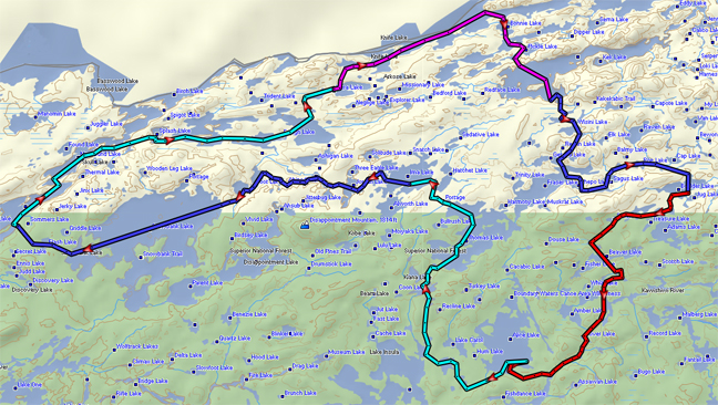
We were one of the first crews on the water Sunday morning, but still experienced lots of traffic as we canoed from Moose Lake through Ensign. But true to form, the harder portage to Vera reduced the crowd significantly and we camped there. Monday's paddle took us over a much traveled route Knife - Bonnie - Pickle - Kekekabic. However, it was far from normal as we saw the devastating effects of the derecho. Much of the portage trails consisted of hiking through fallen trees...sections of the trees had be cut out to allow passage. On both sides of the trail butt ends of the trees were three to four feet above ground. That night we camped in what looked like a field of telephone poles. Unimaginable!
We continued to follow regularly canoed lakes from Kekekabac to Boulder where we camped. The damage from the winds continued, particularly noticeable along the several portage trails. Wednesday we made our swing through the lesser traveled lakes, Smite and Trapline in particular. This was part of the southern loop of the trip and the area did not appear to be has heavily hit as further north where we had be canoeing. We camped at a site Scouts love at the south end of Alice. They always enjoy swimming out to rocks some distance from shore that are just below the surface. They climb up on the rocks to stand. For those passing by, it looks like they are standing on water.
The next to last day had us canoeing to Ima via Hatchet Creek. We were greeted by large waves at the Ima portage trailhead. We could not camp at the trailhead, so made our way to an open campsite where we at lunch and camped for the night. The winds subsided overnight and we had an uneventful paddle through Snowbank and then the portages back to the Canoe Base. Thus concluded a fun BWCAW canoe trip.
A personal note: I always bring a book with to read at camp while the Scouts are fishing, relaxing or whatever. This trip I purchase Sigurd Olsen' Lonely Lands about a trip he took on the Churchill River. That trip was inspired by a trip they had previously taken from International Falls to Lake Superior along the Boundary Waters Fur Trade Route. Paul said he had canoed portions of that route. Brant and I got talking about it and hatched the idea of trying to recruit a group to canoe that route when we got home. Our efforts were successful and we canoed the route in 2000. This lead me to learn more about the fur trade history...which lead to participating in two David Thompson Brigades...which lead to canoeing a portion of the Churchill River route that Olsen canoed...which lead to us being able to participate in Canada's Sesquicentennial celebration in 2017...which lead to... This BWCAW trip opened the door to a fantastic life in retirement.
| Date | Distance (miles) |
Portage Length rods/yards |
Journal Comments | Day's Distance |
Trip Distance |
|
|---|---|---|---|---|---|---|
| |
Sommers Canoe Base to portage and Splash Lake | 6.0 | 35 / 193 | Easy paddle. Heavy traffic | ||
| Splash Lake to portage and Ensign | 0.6 | 5 / 28 | ||||
| Ensign Lake to portage and Vera | 5.0 | 200 / 1100 | Heavy traffic. Steep climb on portage | |||
| Vera Lake to campsite | 0.7 | Ate lunch at campsite. Good fishing | 12.3 | 12.3 | ||
| |
Vera campsite to portage and Knife Lake | 1.3 | 200 / 1100 | |||
| Knife Lake to portage and Bonnie Lake | 3.5 | 33 / 182 | Lunch on Knife Lake | |||
| Bonnie to portage and Spoon Lake | 0.6 | 25 / 138 | ||||
| Spoon Lake to portage and Pickle Lake | 0.4 | 25 / 138 | ||||
| Pickle Lake to portage and Kekekabic Lake | 0.6 | 80 / 440 | ||||
| Kekekabic Lake to campsite | 1.2 | Good lake trout fishing lake. Popular Lake. | 7.6 | 19.9 | ||
| Kekekabic campsite to portage and Stump Lake | 0.6 | 85 / 468 | Portage climbs 21 ft. at start; descends 100 ft at end. | |||
| Stump Lake to portage and Wisini Lake | 0.6 | 10 / 55 | Climbs 17 ft. | |||
| Wisini Lake to portage and Ahmakose Lake | 1.0 | 90 / 495 | One gentle climb, then gentle descent to putin. | |||
| Ahmakose Lake to portage and Gerund Lake | 0.5 | 30 / 165 | ||||
| Gerund Lake to portage and Fraser Lake | 0.3 | 15 / 83 | ||||
| Fraser lake to portage and Shepo Lake | 0.6 | 10 / 55 | ||||
| Shepo Lake to portage and Sagus Lake | 0.4 | 20 / 110 | One campsite on lake | |||
| Shepo Lake to portage and Roe Lake | 1.4 | 42 / 231 | Ate lunch on Sagus Lake | |||
| Roe Lake to portage and Cap Lake | 1.3 | 140 / 770 | ||||
| Cap Lake to portage to Boulder Lake | 1.1 | 200 / 1100 | ||||
| Boulder Lake to campsite | 0.5 | 8.3 | 28.2 | |||
| Boulder Lake campsite to portage and pond | 0.5 | 20 / 110 | ||||
| Pond to Adams Lake | 0.2 | |||||
| Adams Lake to Smite Lake | 1.4 | |||||
| Smite Lake to portage and Beaver Lake | 1.3 | 60 / 330 | ||||
| Beaver Lake to portage and Trapline Lake | 1.6 | 30 / 165 | ||||
| Traplline Lake to portage and Kawishiwi River | 0.8 | 60 / 330 | ||||
| Kawishiwi River to portage | 3.4 | 20 / 110 | Lunch | |||
| Kawishiwi River to portage | 0.8 | 70 / 385 | ||||
| Kawishiwi River to portage | 0.2 | 20 / 110 | ||||
| Kawishiwi River to Alice campsite | 1.3 | 11.5 | 39.7 | |||
| Alice/Kawishiwi River to portage and Insula Lake | 2.2 | 10 / 55 | ||||
| Insula Lake to portage and Kiana Lake | 2.5 | 180 / 990 | Popular lake; southwest part can be confusing. Up hill portage | |||
| Kiana Lake to portage and Thomas Lake | 1.2 | 25 / 138 | ||||
| Thomas Lake to portage and Hatchet River | 2.8 | 5 / 28 | Lake trout in lake. Still some traffic | |||
| Hatchet River to portage | 0.3 | 60 / 330 | Crossed Kekekabic Trail | |||
| Hatchet River to portage and Ima Lake | 0.8 | 50 / 275 | We were able to canoe two portages marked on map | |||
| Ima Lake to campsite | 0.8 | Popular Lake. Ate lunch at campsite. | 10.7 | 50.4 | ||
| Ima Lake campsite to portage and Jordan Lake | 0.7 | 5 / 28 | ||||
| Jordan Lake to portage and Cattyman Lake | 1.7 | 55 / 303 | ||||
| Cattyman Lake to portage and Gibson Lake | 0.5 | 25 / 138 | Low water can expose rocks/stumps; scenic waterfall; steep decent | |||
| Gibson Lake to portage and Swing Lake | 0.4 | 35 / 193 | ||||
| Swing Lake to portage and Abinodji Lake | 0.4 | 50 / 275 | ||||
| Abinodji Lake to portage and Haven Lake | 0.7 | 80 / 440 | ||||
| Haven Lake to portage and Boot Lake | 0.4 | 50 / 275 | ||||
| Boot to portage | 0.6 | 30 / 165 | ||||
| Boot Lake to portage and Snowbank Lake | 0.8 | 50 / 275 | ||||
| Snowbank Lake to portage and Flash Lake | 5.2 | 140 / 770 | Ate lunch on Snowbank | |||
| Flash Lake to portage and Sommers Canoe Base | 1.5 | 320 / 1760 | 12.9 | 63.3 |