SANDIA CREST TRAIL
25-mile Backpack
| Description | Hike the length of the Sandia Mountains following the Crest. The trail offers many spectacular views to both the east and west. Once the steep portions at either end have been hiked, the trail is relatively easy to hike. |
| Difficulty | Moderate |
| Comments | Following the Crest, this trail offers many spectacular views. Because of the change in elevation several different vegetation zones exist on the trail. For large portions of the trail, there is little water. Water is available at the crest and at least one other place along the trail plus at the Tunnel Springs starting point; all water should be purified. Portions of the trail in the crest area are very popular. Extreme care should be taken with fire. |
| To Earn Feather |
Hike Trail 130 starting at either end of the trail; do NOT take the Del Orno route near the north trail head. |
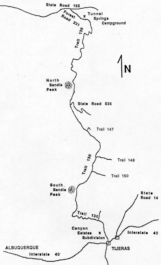
| Maps | Sandia Mountain Wilderness - Cibola National Forest. USGS Placitas, Sandia Crest, Tijeras |
| Trail | Hike Trail 130 starting at either end of the trail; do NOT take the Del Orno route near the north trail head. Note: A descrepency of about 3 miles exists between the published distance for this trail and the distance measured on the Sandia Mountain Wilderness map. The difference is in the South Sandia Crest portion of the trail, but the reason for the difference could not be found. (See map) |
| Elevation Profile |
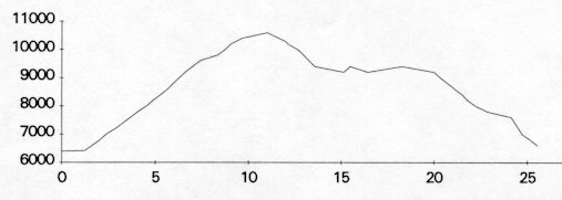 |
| Transportation Requirements |
The north trail head is located at Tunnel Springs Campground. Take NM 165 from Bernalillo east towards Placitas. About 6.8 miles from Bernalillo, turn right (south) on Forest Road 231. Tunnel Springs Campground is at the end of FR 231, about 1 mile from the turnoff. The south trail head is located at Canyon Estates, north of I-40 near Tijeras. Take the Tijeras exit. On the north side of I-40, take FR 519 to Canyon Estates. The trail head is located at the end of the road. |
VEREDAS DE LAS MONTANAS SERIES
(Trails of the Mountains)
EXIT TRAILS
Last updated: November 11, 1998