LA LUZ TRAIL
8-Mile Hike
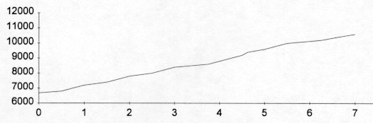
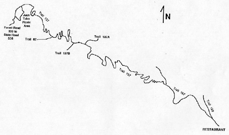
| Description | The La Luz Trail is a special and popular trail that climbs 3700 feet in just over seven miles. It offers views of Albuquerque and the Rio Grande Valley, rugged canyons and dense forests. The trails starts near the Juan Tabo Picnic Area and ends near the Tramway Terminal. |
| Difficulty | Difficult |
| Comments | The trail has been relocated in places. The USGS map shows the old trail and should be used as a reference only. Follow the trail marked on the Sandia District Forest Service map. DO NOT CUT THE SWITCH BACKS ASSOCIATED WITH THE ORIGINAL TRAIL. You should start hiking the trail early in the morning to avoid the hot sun at the lower portion of the trail. Sufficient water (2 quarts per person) should be carried as the spring about a third of the way up the trail is intermittent. The mammals in this area are known for carrying the plague; stay away from all critters on or near the trail. |
| To Earn Feather |
Hike trail from Juan Tabo Picnic Area to the Crest. Return hike is optional. |
| Maps | Cibola National Forest -- Sandia Ranger District; Sandia Mountain Wilderness. USGS Sandia Crest |
| Trail | From Trail Head at Juan Tabo Recreation Area: Forest Service Trail 137 (7.0 mi.) -> Trail 82 (0.5 mi.) -> Crest Trail 137 (0.5 mi.) -> Tramway Terminal. (See map) |
| Elevation Profile |
 |
| Transportation Requirements |
Drive to the Juan Tabo Picnic Area. Just before the picnic area, take Forest Service Road 333A to the parking area for Trail 137. If the trail is hiked one-way only, hikers can be picked up at Sandia Crest via NM 536 or the Tram can be taken back to the Tram parking lot east of Tramway Blvd. If the Tram is taken back, cars must be ferried from the starting point to the Tram parking lot or you must hike about 3 miles along the Tram Trail to the 137 trail head. |
VEREDAS DE LAS MONTANAS SERIES
(Trails of the Mountains)
EXIT TRAILS
Last updated: November 11, 1998