HIGHLINE LOOP TRAIL
23-Mile Backpack
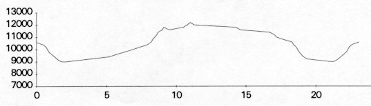
| Description | The Highline Loop Trail is located in the San Juan National Forest and offers the opportunity to explore the rugged San Juan National Forest with the middle portion of the trail located above 11000 ft. elevation. This portion of the trail, the Indian Trail Ridge, was used by historic and prehistoric humans. Spectacular views are common on this hike. |
| Difficulty | Difficult |
| Comments | This trail offers the opportunity to hike through varied terrain -- along streams with opportunities for fishing, a side trip to climb Sharkstooth and/or Centennial Peaks (not required to earn segment), and through tundra and forested areas. You have your choice of campsites along Bear Creek and at Taylor and Grindstone Lake; if you chose to camp at Grindstone Lake, be on the lookout for the cutoff to the lake; it is easy to miss.>BR> While hiking along Trail 520, you are exposed to the elements. Be prepared for lightening or snow or both at the same time! You can encounter snow any month of the year. If you chose to climb either of the mountain peaks, be careful of areas with very loose rock. |
| To Earn Feather |
Hike trail as described. Side trip to Sharktooth or Centennial Peak is NOT required. |
| Maps | San Juan National Forest; USGS maps La Plata, Colo., Orphan Butte, Colo. |
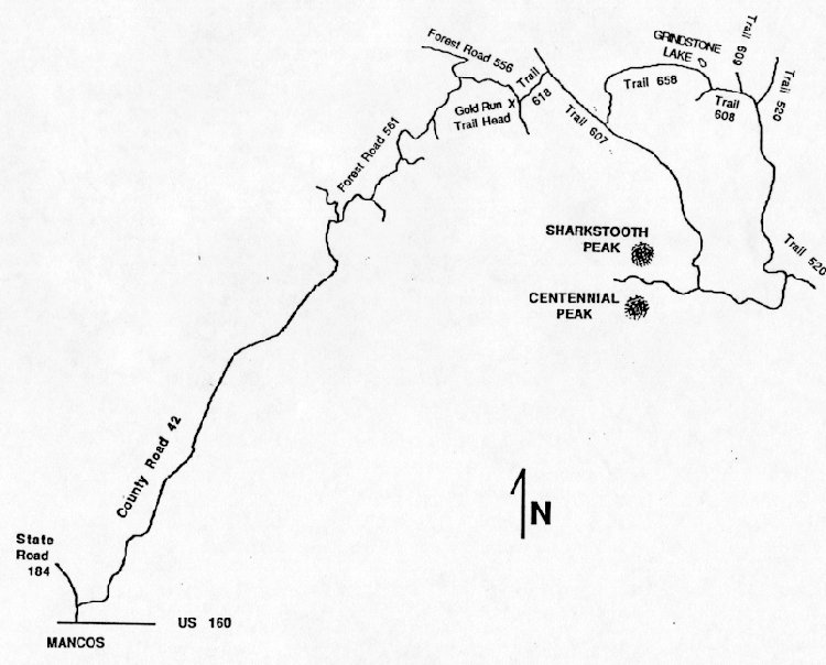
| Trail | From the Gold Run Trail Head Trail 618 (2.1 mi.) -> Trail 607 (8.9 mi.) -> Trail 520 (3.4 mi.) -> Trail 608 (0.6 mi.) -> Trail 658 (4.4 mi.) -> Trail 607 (1.6 mi.) -> Trail 618 (2.1 mi.) -> Trail Head. (See map) |
| Elevation Profile |
 |
| Transportation Requirements |
From Mancos, CO turn north on CO 184. Go about 1/4 mile to County Road 42 which becomes Forest Road 561. Go past Jackson Gulch campground and Jersey Jim Lookout to Forest Road 556. Turn right to the Gold Run Trail Head |
VEREDAS DE LAS MONTANAS SERIES
(Trails of the Mountains)
EXIT TRAILS
Last updated: November 11, 1998