CLAYTON CAMP
12-mile Backpack/Hike Combination
| Description | This hike in the Valle Vidal Unit of the Carson National Forest is suitable for all Scouts. It includes a short backpack to base camp, a hike through Costilla Pass and Valle Vidal with the possibility of seeing large elk herds, and a backpack out. Trout fishing exists for the fishermen in the troop. Numerous side hikes also are available. |
| Difficulty | Easy |
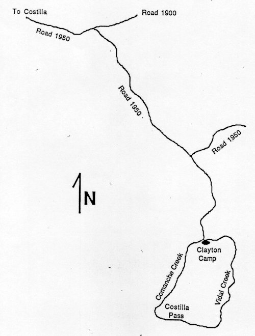
| Comments | There is considerable disagreement between the USGS maps and the Forest Service map of this area. Old roads are being closed; some are being shown as trails and some are not even shown on the Forest Service map. None of the trails have trail numbers (1987 edition). From the starting point, follow the trail to Clayton Camp. A large cabin exists at the site which can provide shelter in inclement weather. However, be careful as the building is infested with rats. Thus use tents at this base camp. From the base camp, hike to the Valle Vidal area passing through Costilla Pass; turn left at the fence line. The USGS map shows several old roads in the area just before the pass. Once into the Valle Vidal, be on the lookout for large herds of elk. Returning to Clayton Camp, be on the look out for the intersection to camp. The Forest Service map does not show an intersection, but the USGS map does; you want to follow the main water drainage to Clayton Cabin. Hike out to the cars by the same route you came in. An alternate route out is go back to the "intersection" previously discussed (USGS map) and hike northeast to the intersection of FR 1950. But take note, this portion of FR 1950 is only shown on the Forest Service map! Sound Confusing? It is. But the beauty of this area, large elk herds and good fishing more than make up for the map confusion. It is an excellent backpack for younger scouts with lots of opportunities to explore for the older members of your troop. |
| To Earn Feather |
Backpack to Clayton Camp, hike/backpack through Valle Vidal and then return to the cars. Camp at least one night. |
| Maps | Carson National Forest. USGS: Red River Pass, Comanche Point |
| Trail | From the gate near the intersection of Comanche and Holman Creeks (2.5 mi.) -> Clayton Camp (2.7 mi.) -> Costilla Peak (0.9 mi.) -> Valle Vidal ( 2.7 mi.) -> intersection of trail to Clayton Camp (0.8 mi.) -> Clayton Camp (2.5 mi.) -> FR 1950. (See map) |
| Elevation Profile |
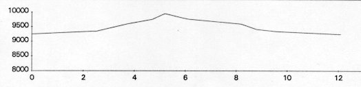 |
| Transportation Requirements |
At Costilla, turn east from NM 522 on to NM 196. NM 196 becomes Forest Road 1950. FR 1950 intersects FR 1900 at Comanche Point. Follow FR 1950 to the right (south) about 4.5 mi. to a small corral near the stream and a sharp (about 90 degrees) turn in the road; do not make the sharp turn heading up hill at this point. A gate prevents you from continuing in the direction you were going. Park you car at this point and start hiking. |
VEREDAS DE LAS MONTANAS SERIES
(Trails of the Mountains)
EXIT TRAILS
Last updated: November 11, 1998