CABRESTO LAKE
13-Mile Backpack
| Description | Backpack the high Alpine country of New Mexico in the Latir Wilderness Area of the Carson National Forest. The trail takes you into an area with several peaks over 12,000 ft. elevation and tundra above the tree line. The Latir Lakes are also accessible from the trail. |
| Difficulty | Difficult |
| Comments | The trail climbs over 3000 feet in about six miles which makes this a trail for older Scouts who are in good condition. Safe backpacking in this area requires being prepared for sudden weather changes, including snow in any month of the year, and careful planning to avoid exposed areas when the probability of lightening is high. Adequate water must be drunk to prevent dehydration and altitude sickness. The trails follow steams much of the way, but water must be carried while hiking the upper portion of Trial 85. A side hike to Latir Lakes can be made, but these lakes are on private land and permission must be obtained in advance (Rio Costilla Coop Livestock Association, Costilla, NM) . |
| To Earn Feather |
Hike the trail as described passing Baldy Cabin and Heart Lake and crossing Latir Mesa. |
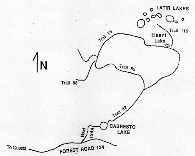
| Maps | Carson National Forest, Latir Peak and Wheeler Peak Wilderness. USGS: Latir Peak |
| Trail | Starting at the Cabresto Lake Campground, Trail 82 (4.1 mi.) -> Trail 85 at Baldy Cabin (6.5 mi.) -> Trail 82 (2.6 mi.) -> Cabresto Lake. (See map) |
| Elevation Profile |
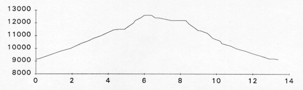 |
| Transportation Requirements |
From State Road 522, take State Road 38 in Questa, NM, approximately 0.5 miles to Forest Road 134. Follow FR 134 to FR 134A. A parking area is available at this intersection for vehicles with low clearance. Follow FR 134A about one mile to the Cabresto Lake campground. |
VEREDAS DE LAS MONTANAS SERIES
(Trails of the Mountains)
EXIT TRAILS
Last updated: November 11, 1998