BEATTY'S LAKE
22-mile Backpack
| Description | Backpack in the Valle Vidal area adjacent in an area used by Philmont crews. The terrain is relatively gentle giving the opportunity for a longer backpack without experiencing large elevation changes. The area is noted for its scenery, wildlife and outstanding fishing. |
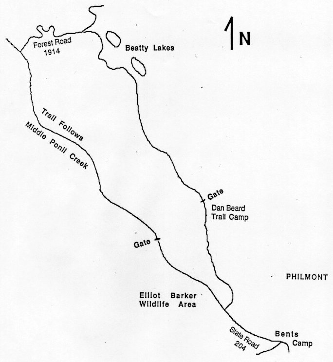
| Difficulty | Moderate |
| Comments | The Valle Vidal area was given to the Forest Service by Pennzoil Company in 1982. Roads exist through the area, but motorized traffic is restricted. Thus what might show as a road on USGS maps is shown as a trail on the Forest Service map. Since no trail numbers have been established, care must be taken to look for key geographical features at intersections. The first is the trail intersection at Greenwood Canyon; be sure to follow the old wagon trail north. At the junction of Forest Road 1910 and 1914, turn right and cross the bridge. The intersection before Beatty's Lakes occurs near a pond on the left (north) side of the road. Take the right road past the gate and the lakes themselves (on the left/east). The trail follows the drainage that eventually becomes Bonita Canyon. You will cross through a corner of Philmont and pass the Dan Beard Camp. The trail then follows the Philmont/Elliot Barker Wildlife Area boundary. All camping should be done in the Valle Vidal Area; do not camp in Philmont or Elliot Barker. It is suggested that this hike not be taken during hunting season. Be sure to check for special fishing regulations for this area. Expect numerous stream crossings in the first part of the hike; some may be a few feet deep depending on the time of the year. |
| To Earn Feather |
Backpack the trail as described and camp at least one night. |
| Maps | Carson National Forest. USGS: Bald Mountain, Abreu Canyon |
| Trail | From the end of NM 204 (4.4 mi.) -> Greenwood Canyon (2.4 mi.) -> Forest Road 1910/1914 (3.0 mi.) -> Trail intersection at Beatty's Lakes (6.2 mi.) -> Philmont Boundary (0.4 mi.) -> Elliot Barker Wildlife Area (2.8 mi.) -> NM 204 (3.0 mi.) -> End of NM 204. (See map) |
| Elevation Profile |
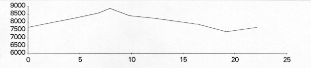 |
| Transportation Requirements |
From Cimmaron, NM, take US 64 northeast to NM 204. Turn left (northwest) and drive past Philmont's Ponil Camp and the Stern Ranch to the end of NM 204. This is about 16 miles. Vehicle access may be limited during the spring run off. |
VEREDAS DE LAS MONTANAS SERIES
(Trails of the Mountains)
EXIT TRAILS
Last updated: November 11, 1998