RIO MEDIO/BORREGO MESA
20 miles
| Description | This trail features hiking along the Rio Medio to the Pecos high country. The later portion of the hike will require good map and compass skills. |
| Difficulty | Difficult |
| Comments | The trail follows the Rio Medio, crossing it several times, so expect wet feet. The trails near the upper portions of both options are difficult to follow and may require some cross country hiking. No camping is allowed in lake basins. Note: Trail 155 from the intersection of Trail 355 to Trailrider's Wall, Trail 351A and the upper portions of Trail 151 are not shown on the USCS Truchas Peak (1963) map. Trail 151 is very difficult to follow and requires good map and compass skills. Some trail guides do not recommend hiking this trail because of the difficulty in following it. There is little or no water on the second half of the trail. |
| To Earn Segment |
Hike as described. |
| Maps | USGS 7-1/21 Sierra Mosca, Truchas Peak |
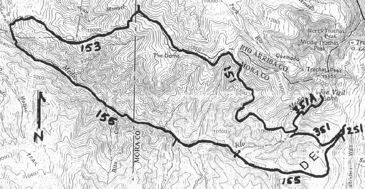
| Trail | From Borrego Mesa Campground: Trail 155 (9.7 mi.) -> Trail 251 (0.1 mi.) -> Trail 351 (1.3 mi.) -> Trail 351A (1.6 mi.) -> Joe Vigil Lake. Trail 351A (1.6 mi.) -> Trail 151 (6.3 mi.) -> Trail 153 (3.5 mi.) -> Borrego Mesa Campground. (See map) |
| Elevation Profile |
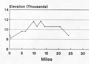 |
| Transportation Requirements |
Cars should not be left unattended at the Borrego Mesa Campground. |
PECOS WILDERNESS TRAILS SERIES
EXIT TRAILS
Last updated: November 11, 1998