NAMBE LAKE
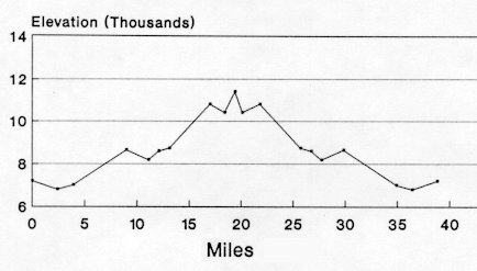
39 miles
| Description | A challenging backpack for the summer and fall. It traverses rugged terrain with little level hiking. Trail junctions are difficult to find in some location. This is a trail for experienced hikers. |
| Difficulty | Difficult |
| Comments | Spring run-off and the necessity to cross rivers several times make this a trail to hike in the summer and fall. Trail 400 to Nambe Lake does not follow the path shown and the Pecos Wilderness map, but rather follows the Rio Nambe to the lake; there are parallel trails in this area. No camping or fires are permitted in the Nambe Lake basin. If alternate routes are taken on the return to Camp Frank Rand, be sure to research the route ahead of time. Trials in this area tend to be very rugged and poorly marked in many cases. |
| To Earn Segment |
Hike route as described. Returning to Camp Frank Rand by alternate routes is acceptable. |
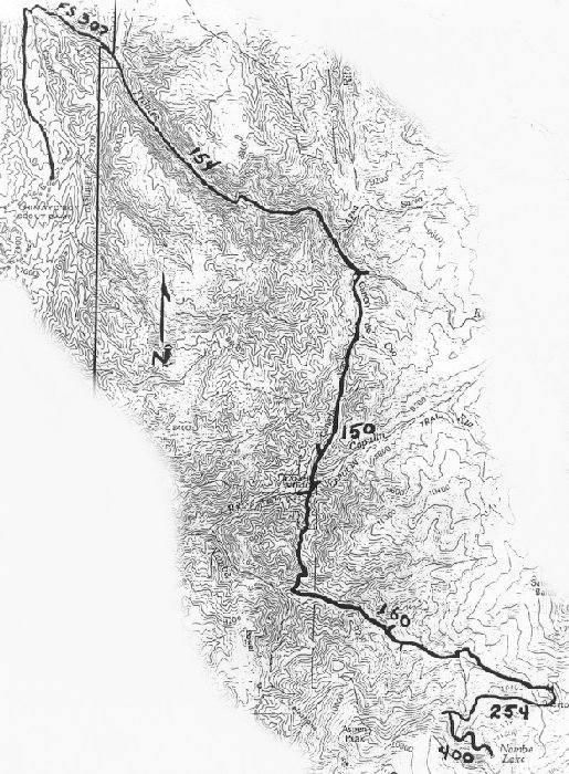
| Maps | USGS 7-1/21 Cundiyo, Sierra Mosca, Aspen Basin |
| Trail | Starting at Camp Frank Rand: Hike north (2.4 mi.) -> Forest Service Road 307 (1.5 mi.) -> Trail 154 (5.1 mi.) -> Trail 150 (4.1 mi.) -> Trail 160 (3.9 mi.) -> Trail 254 (1.4 mi.) -> Trail 400 (1.0 mi.) -> Nambe Lake. Return to Camp Frank Rand via same route. (See map) |
| Elevation Profile |
 |
| Transportation Requirements |
Parking is available at Camp Frank Rand. Arrangements should be made with the camp ranger. |
PECOS WILDERNESS TRAILS SERIES
EXIT TRAILS
Last updated: November 11, 1998