RIO MOLINO
36 miles
| Description | The Rio Molino Trail segment offers a variety of hiking conditions fording of streams, elevation changes requiring hiking of switch backs, areas of gentle grades and areas where good orienteering skills are required. |
| Difficulty | Difficult |
| Comments | This trail should only be hiked in summer and fall. Run-off water can make the Rio Frijoles portion very wet to hike and dangerous if the run-off is high. Portions of both Trail 227 and 228 can be hard to follow and cross country hiking may be required on Trail 227. Trail 227 is not recommended by the Pecos Wilderness Trail Guide. |
| To Earn Segment |
Hike trail as described. |
| Maps | USGS 7-1/2' Cundiyo, Sierra Mosca |
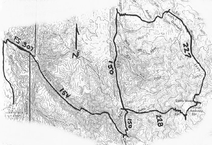
| Trail | Starting at Camp Frank Rand: Hike north (2.4 mi.) -> Forest Service Road 307 (1.5 mi.) -> Trail 154 (5.1 mi.) -> Trail 150 (1.8 mi.) -> Trail 228 (3.9 mi.) -> Trail 227 (7.1 mi.) -> Trail 150 (5.4 mi.) -> Trail 154 (5.1 mi.) -> Forest Service Road 307 (1.5 mi) -> trail to camp (2.4 mi.) -> Camp Frank Rand. (See map) |
| Elevation Profile |
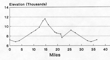 |
| Transportation Requirements |
Cars can be parked at Camp Frank Rand. Arrangements need to be made with the camp ranger. |
PECOS WILDERNESS TRAILS SERIES
EXIT TRAILS
Last updated: November 11, 1998