VALLE LARGO
16 miles
| Description | This is an easy trail to hike with few steep areas. However, good map and compass skills are required because of poor trail definition in some areas. The trail follows rivers and passes thru both dense forests and high meadow areas. |
| Difficulty | Moderate |
| Comments | The trail is relatively easy hiking, but there are problems with losing the trail near the head of Rito Los Esteros and in the Valle Largo meadows. Camping is extremely heavy in the Mora Flats area (intersection of trails 250 and 240). The remainder of this trail is only used moderately. In periods of heavy run-off, the Rio Mora may be dangerous to cross. Also, do not be in the large meadow areas during thunderstorms. There is little water at the top of the loop. |
| To Earn Segment |
Hike trail as described. |
| Maps | USGS 7-1/21 Cowles, Aspen Basin |
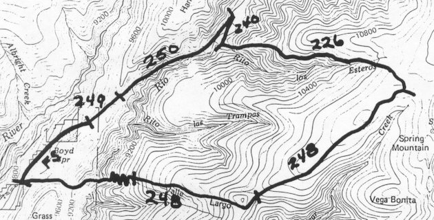
| Trail | From Iron Gate Campground: Trail 249 (0.9 mi.)Trail 250 (2.2 mi.) -> Trail 240 (1.0 mi.) -> Trail 226 (3.0 mi.) -> Trail 248 (7.3 mi.) -> Forest Service Road (1.3 mi.) -> Iron Gate Campground. (See map) |
| Elevation Profile |
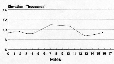 |
| Transportation Requirements |
Parking is available at the Iron Gate Campground. |
PECOS WILDERNESS TRAILS SERIES
EXIT TRAILS
Last updated: November 11, 1998